Tags
Greece, Jebel Akhdar, Jordan, Nepal, Oman, weekly photo challenge
Saturday, May 4: This week’s WordPress Weekly Photo Challenge is From Above: Change your perspective on something. Share a photo of a subject which you shot from directly above.
04 Saturday May 2013
Tags
Greece, Jebel Akhdar, Jordan, Nepal, Oman, weekly photo challenge
Saturday, May 4: This week’s WordPress Weekly Photo Challenge is From Above: Change your perspective on something. Share a photo of a subject which you shot from directly above.
16 Saturday Jun 2012
Posted Al Ain, Mezyad Border Crossing, Musandam, Oman, Six Word Saturday, UAE, United Arab Emirates
inSaturday, June 16: Today is Six Word Saturday and this question sums up my day:
Where did the Oman border go?
We drove up to Musandam this long weekend for the holiday of Leilat al-Meiraj (the Ascension of the Prophet). Musandam is at the northeastern most tip of the Arabian peninsula and is separated from the rest of Oman by a wide expanse of United Arab Emirates (UAE) territory. In order to get there, you can either take a plane or a ferry between Muscat and Khasab, OR you can drive, crossing the border from Oman to UAE, and then crossing again from UAE to Oman and into Musandam. It was no problem on the way there Thursday (well, almost no problem), taking about 1 1/2 hours of driving through UAE on a moderately traveled six-lane highway through salmon-colored sand dunes.
On the way back Saturday, however, we were using my friend’s GPS, which led us to miss the bypass road and put us right in the thick of the traffic going into Dubai. After much backtracking, taking wrong turns, and arguing about the proper way to go, we ended up finally at Al Ain, UAE. When we got there, we proceeded to the Hilli border crossing, not knowing the roads from that crossing would lead us to Sohar in the north of Oman; once we entered the compound, it seemed there was no escaping. We were told that to go to Nizwa, we needed to cross at another border, quite some distance away, because the roads from the Hilli border would add 4-5 hours to our drive to Nizwa. The problem was that once we got into the compound, merging into a three-lane wide line of cars coming from Oman to UAE, we felt like we had entered the Twilight Zone and we might never get out! It was a long story, the details of which I don’t want to get into here, but after much misdirection and confusion, we finally escaped back into UAE, where we searched long and far afield for the elusive crossing at Mezyad, which doesn’t seem to have any signs until you get within 5km of the crossing. Uncountable kilometers out of Al-Ain, we arrived at the border at Mezyad, where we crossed without incident into Oman, headed toward Ibri. All in all, we spent a total of 6 hours in UAE on various wild goose chases, where we only spent 1 1/2 hours in UAE on the way north!!
Grrrrr…….
16 Saturday Jun 2012
Posted Al Qala's Fort, Bukha, Bukha Fort, mosque, Musandam, Oman
inTags
Saturday, June 16: After visiting Khasab Fort, we begin our long drive back to Nizwa, making a stop about 25km south of Khasab in the modest little town of Bukha.
We first drive up to a little hilltop where we find the ruins of Al Qala’s Fort, which overlooks the town. There isn’t much here except the ruins of an old watchtower and a great view of the bay.
After probing around in the ruins and admiring the view of the date palm plantations in one direction and the Arabian Gulf on the other, we drive down to the old Bukha Fort, which sits right along the coastal highway. When the fort was built in the 16th century, it stood right on the shore, but now the water has receded. The fort is surrounded on three sides by a dry moat where, according to legend, prisoners were once chained to drown in the rising tide.
Boxy rectangular towers sit on opposite corners of the fort. The southeastern tower is circular and curved inward at the top to reduce the impact of cannonballs.
Behind the fort sits the town’s old mosque that is unusual in that it looks more like a house than a place of worship and lacks both a dome and minaret.
After we pass through Bukha, we head on our merry way home, across the UAE border, through UAE, and back to Oman, after a very convoluted route!
16 Saturday Jun 2012
Posted Khasab, Khasab Castle, Musandam, Oman, Travel
inTags
Saturday, June 16: This morning we check out of the hotel and go directly to Khasab Castle. We debate about whether to go in, because it costs 500 baisas and because it’s steamy hot. We’d frankly rather snap a few photos and hop back in the air-conditioned car. But, since we’re here, we decide to brave the elements and venture into the castle. A pleasant surprise awaits us inside.
Khasab Castle was built by the Portuguese in the 17th century in their bid to control regional maritime trade. Later it was modified by Omani forces. Originally on the sea front, the waters have gradually receded a considerable distance, leaving the castle quite far inland.
A couple of large wooden dhows stand outside.
Inside the courtyard of the castle we encounter three more boats — a battil, mashuwwah and zaruqah.
The battil vessels were noted for their speed and were popular for fighting and smuggling as well as for fishing, pearling and coastal trading. This boat was built in Kumzar around 1970. The battil has a pretty cowrie-shell decoration around the prow and rudder which are typical of Musandam.
The mashuwwah is an adaptation of earlier, double-ended vessels. It can be rowed, sailed, or fitted with an outboard engine. This mashuwwah was used in Khasab harbor to ferry goods and people back and forth between anchorage and shore. In days past, such vessels were used as “ship’s boats” on ocean-going cargo dhows where they served as lifeboats and provided a means of communicating between ships at sea. During the long sail to east African ports, the ship’s carpenter would often use his spare time on board to build a mashuwwah to sell at the end of the voyage.
Vessels of the zaruqah class such as this one built in Khasab in the mid-1900s are still a common sight in the bays of Musandam where they are the favored fishing vessel. They are quiet in the water and easy to maneuver and are suitable for use by a single fisherman or a crew of up to four oarsmen and 2-4 net handlers. A shoal of fish venturing into one of Musandam’s deep bays can be rapidly encircled by nets laid out by a zaruqah. A spotter is often positioned high in the adjacent cliffs to help guide the crew to their catch.
Also in the courtyard is a modern replica of a traditional barasti (palm thatch) summer-house, constructed using stone pillars with permeable walls made from palm branches.
I walk up some steps to a walkway where I can make a circuit of the fort and its towers, some with mangrove-pole ladders set into the interior walls. I dip into one room along the walkway where it is refreshingly cool. I go inside to refresh myself and let the sweat dry off.
Going back out into the heat, I walk along the walkway into a tower where there are displays on traditional Musandam culture featuring colorful rugs, crockery and some mannequins. One display is of an apothecary’s shop.
A large and completely detached circular tower stands in the center of the courtyard. This is meant to provide an additional refuge in case the outer walls are breached. Inside this tower are informative and interesting exhibits covering various aspects of Musandam’s geology, culture and history.
The massive central tower is believed to predate the castle itself.
15 Friday Jun 2012
Posted Camels, dates, Dhofar Region, dhow, Khasab, Musandam, Musandam, postaweek2012, Salalah, University of Nizwa, Weekly Photo Challenge
inFriday, June 15: This week’s photo challenge is Close. It’s a feeling, it’s a proximity…it’s people, it’s a place, it’s objects. They’re close.
Here are some dates found on date palms on the University of Nizwa campus. They are clustered together, as close as close can be.
A mother and baby camel in Salalah who are quite close.
Finally, I went on a dhow cruise in Musandam over the holiday for the Prophet’s Ascension. Omani families are very close, and I love the picture of this father and daughter.
15 Friday Jun 2012
Posted A'Rahaybah, A'Saye, cemetery, Jebel Harim, Musandam, Oman, petroglyphs
inFriday, June 15: After returning from the dhow cruise, we head out for another drive into the mountains toward the highest point in Musandam, Jebel Harim. Basically, we drive back over the same mountain road we drove on last evening, but this time, as we have more time before sunset, we continue further on the road to see the petroglyphs, incredible mountain views, a graveyard, and the border to Dibba.
The highest point of the road is below the summit of Jebel Harim, meaning “Mountain of Women.” This mountain, at 2,087m, is the highest point in Musandam. The mountain is so named because back in the day, when their menfolk were out on long fishing or trading expeditions, the local women retreated into the caves of these mountains to avoid being abducted by pirates or rival tribes.
The actual summit of the mountain is home to a radar station that monitors shipping through the Strait of Hormuz; of course this station is out-of-bounds.
The highest point of the road at around 1,600m runs beside an air-traffic control radar installation, and just below that is an area where there are some petroglyphs carved into boulders strewn around a huge rounded field. From Wikipedia: “Petroglyphs (also called rock engravings) are pictogram and logogram images created by removing part of a rock surface by incising, picking, carving, and abrading. Petroglyphs are found world-wide, and are often associated with prehistoric peoples.”
There are no signs to lead us to where these petroglyphs are located, but Tom has been here before and he thinks he remembers where they are. He says they are marked by little piles of stones that people have constructed. We spend quite some time walking around looking for these elusive things, but we’re unable to find them. After a while, I tire of the search because I’m not even sure what I’m looking for. Tom says he didn’t come all the way up here to leave without seeing them, so I go and sit near the car while he wanders around looking for them.
Luckily, as I’m sitting near the car, an Indian guide on a “mountain safari” with two Indian tourists from Dubai drives up. Tom is out of sight by this time. I jump up and ask the guide if I can follow him unobtrusively to where the petroglyphs are. “Don’t worry, I won’t intrude on your tour!” He and his two Indian guests are not at all bothered to have me along as a third wheel…. 🙂
The guide has two bottles of water with him and I follow him just a hop, skip & a jump from the car, where there is a large flat boulder. The guide pours some of the water on the boulder, which shows off the petroglyphs nicely. Ah, so that’s what they look like! I yell to Tom, who is still doggedly looking on the far reaches of the boulder field, and tell him to come see the rudimentary weathered images chipped out of the stone, including matchstick human figures beside animals such as oryx, Arabian leopards and gazelle. There is even what looks to be a man on an elephant, or some unidentified animal. Cool!
Most of these petroglyphs have been carved out of stone using sharp bronze, iron or stone tools and highlighted with a white pigment made from coral. Dating these images is difficult. However, since most of them depict people or animals, it’s guessed that they probably pre-date Islam (which prohibits the making of images of living creatures).
We drive along a ridgetop and then descend into the wide bed of Wadi Rawdah, with limestone cliffs surrounding us.
We come across an interesting cemetery with neat lines of headstones carved out of rough-hewn slabs of stone. Apparently this bowl was used as a tribal battleground, thus accounting for the large numbers of people buried here. This cemetery is quite different from the regular Islamic cemeteries I’ve seen throughout Oman. See the nizwa cemetery.
We drive onward hoping to get to Dibba so we can see the very exclusive resort of Six Senses Zighy Bay. This resort is hidden on the coast, a 23km drive north of Dibba (4WD required). Apparently guests approaching by road have the option of making the last part of the journey by tandem paraglide (!!!). That sounds interesting enough to entice us to explore this place; however, when we get to the Dibba border, we are sternly told we are not allowed to cross because we’re not GCC nationals. So, we turn around and head back the way we came, up to the ridge and back along the road beneath Jebel Harim, all the way back to Khasab. By the time we are halfway back, it is dark outside and just a little perilous driving out of the mountains.
Dinner again at Al Shamaliah and then back to Nizwa tomorrow… 🙂
15 Friday Jun 2012
Posted dhow, Dolphin Tourism and Travel, Khor Ash Sham, Musandam, Oman
inFriday, June 15: We head out at 9:00 this morning on a dhow cruise through Khor As Sham, a sheltered 17km long fjord. The traditional dhow has been used in trading in Oman for centuries; historically it has weathered storms to reach ports in Iran, India, South-East Asia and further down the African coast in Zanzibar.
The cruise is organized through Dolphin Tourism and Travel, and upon boarding, we find a beautiful wooden boat with carpets and cushions inviting us to lounge and enjoy. The crew loads up the boat with apples, bananas, soft drinks and water for our 3 hour cruise through Khor Ash Sham, where we will have the chance to see small villages, snorkel and swim, and see dolphins.
It’s hot. And that is an understatement. It’s only a little after 9:00 when we board and already it’s sweltering. There isn’t a huge crowd on board, because honestly, this isn’t the time of year most people come north to Musandam. Most people in Oman, during the hot summer months, head south to Salalah, where the khareef brings the sweet relief of rain, clouds and cool weather.
However, we have been granted a holiday for the Prophet’s Ascension, and we can never pass up the chance to travel on a holiday. Even if it’s to a sauna-like climate. It’s already bad enough being cooped up in our air-conditioned houses during the summer months, bringing on delirious bouts of cabin fever. Sometimes, we must simply escape.
Thankfully, we don’t linger too long at the dock, because standstill temperatures are unbearable. Once the boat gets moving, we at least have a hot breeze. I figure moving air is better than still air, any day. We sail out into what is commonly known as “The Norway of Arabia,” a “magical combination of mountain and maritime landscapes.” (The Rough Guide to Oman)
The water is clear and calm and the red-rock Hajar mountains drop dramatically into the blue waters of the Arabian Gulf, which reflect them back to travelers. These precipitous mountains create a maze-like system of steep-sided fjords (khors), cliffs and islands, most of them inaccessible except by boat.
The peninsula’s landscape, like the rest of Oman’s, is the result of crazy geological processes: “the khors themselves are actually flooded valleys, formed as a result of Musandam’s progressive subduction beneath the Eurasian continental plate, which is causing the entire peninsula to tilt down into the sea at the dramatic rate of 5mm a year.” (The Rough Guide to Oman)
On our cruise, we pass interesting bare and craggy rocks, with inlets that house small villages of just around 10 families each. Each little fishing village is accessible only by boat. All water must be shipped in by boat and children are taken to school by boat to Khasab. Many of the younger generation, bored by life in these secluded villages, opt to escape to more populated areas; those fishermen who remain behind only stay in their villages for 6 months of the year. They move to Khasab for the harvest when the water becomes too hot for fish.
The first village we pass by is Nadifi, with around 100 inhabitants, mainly fishermen. With no land access, most villagers own speed boats.
Qanaha is a small fishing village where the stone houses blend into the cliffs, made from local stone. In the old days, this was the first line of defense, not to be seen.
Maqlab is a mountain village where the people earn their living by goat herding and fishing. This small village is made up of only 10 houses.
Telegraph Island (Jazirat al Maqlab) is the most famous landmark in the area. Here the British government laid the first telegraph cable in 1864; it ran from Bombay, India to Basra, Iraq and onwards to London. This island was manned for only about 10 years.
Here we stop to snorkel and swim. I am the only woman who gets in the water here. I think it’s a no-brainer to get in the water as the alternative is to sit and swelter for an hour while the boat is anchored. We explore a small coral reef where we can see schools of blue & yellow striped fish and prickly sea urchins on the rocks. Apparently some of the marine life also includes butterfly fish groupers, barnacles, and coral growths.
All the islands and villages have no road connection and shops, schools, and hospital are only accessible by boat. The children travel by boat to school and stay over in Khasab from Saturday to Wednesday morning. In all villages you can see water tanks. The Oman government provides fresh water free of charge on a regular basis.
After swimming and snorkeling for nearly an hour, we climb back into the boat and head back to Khasab. On the way, we encounter numerous dolphins who swim along beside the boats. Dolphins are apparently attracted by the sounds of the boats’ engines and the water churned up in their wake. We enjoy hanging out over the boat and watching them as they playfully dip in and out of the water. It seems effortless for them to keep up with the dhow.
It’s a lovely morning exploring the “fjords of Arabia.”
14 Thursday Jun 2012
Posted A'Rahaybah, A'Saye, acacia forest, Al Shamaliah, Jebel Harim, Khor an Najd, Musandam, Oman, Sal al Asfal, Shehi, Wadi Khasab
inThursday, June 14: After we check in to the Khasab Hotel, we take a drive to get our first glimpse of what Musandam has to offer. Tom has been here before, so he knows the sights to see.
We first follow the paved road from the southern end of Khasab down through the broad Wadi Khasab. Khasab, in Arabic, means “fertility,” and the rich soil that washes down from the mountains here contributes to the area’s agricultural prosperity. Apparently, the wadi has also been the source of destructive flash floods; a dam built in 1986 now protects the town.
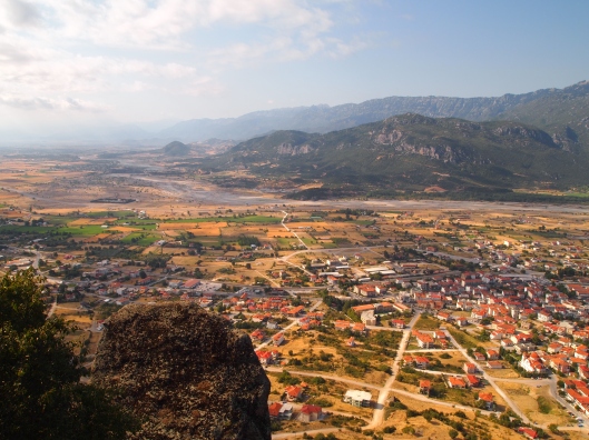
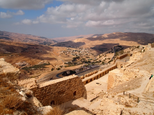
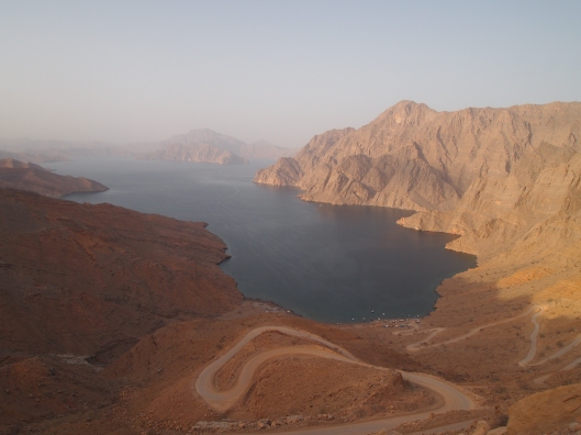
Past the exit toward Dibba, a far-flung border post back into the UAE, we enter an area known as Sal al Asfal (“Lower Plain”), a flat plain that was formerly sea bed. Here, we head off on a dirt road to the left past a military firing range toward Khor an Najd. Tom says he’s heard it called Hidden Cove. We make a steep climb in Tom’s 4WD to the crest of the ridge, from where we can see the khor far below and the road, full of switchbacks, leading to a small piece of ugly beach, lined with fishing boats and dotted with rubbish.
The views from the top are amazing. However, when we wind our way down the precipitous hairpin turns on the dirt road to the beach, we are disgusted by the smell and the sight of litter. It is really a shame that this beach is not kept clean as it is the only beach accessible by car in the fjords.
After our little journey, we drive further into the depths of Sal al Asfal, where we come across an acacia “forest,” reminding me of an African savannah in the middle of Arabia. Though we don’t see any goats this evening, apparently goats roam here and feast on the acacia leaves, leaving the lower branches on the trees stripped bare to a certain height. It’s a lovely and shady area, in the shadow of the mountains. At this point, Tom breaks out a couple of beers for us to enjoy… 🙂
After this Tom wants to drive up into the mountains leading to Jebel Harim. It is getting late in the day, but he’s hoping to reach the high point, where there is an amazing view, right at sunset. We drive up a well-maintained and graded dirt road, climbing and climbing until we can see increasingly panoramic views of the surrounding mountains. According to The Rough Guide to Oman, “most of these are an enormous mass of stratified, greyish limestone, interrupted in places by pockmarked extrusions of gloopy-looking substance, like a kind of geological cheese fondue. The porous rock is riddled with caves, many of which were formerly occupied by the reclusive Shehi.”
According to The Rough Guide, the Shehi are the largest of three main tribes in Musandam. They formerly had a “mysterious and fearsome reputation, said to speak a language unintelligible to anyone but themselves and living a reclusive life up in the mountains , ekeing a frugal and difficult existence out of one of Arabia’s most inhospitable environments. Notably different from the Bedu and townspeople of the plains, many of the Shehi formerly lived in mountain caves or natural rock shelters, which were converted into simple little dwellings with the addition of a couple of stone walls and wooden doors.”
No one is certain where the Shehi originated, but there are several theories. One is that they were original inhabitants of Oman gradually driven north by Yemenis and Nizari Arabs arriving from the south. Another interesting tradition has it that they are the descendents of survivors of shipwrecks marooned on the coast of Musandam over the years. The Shehi remain the dominant clan in contemporary Khasab.
We pass through the village of A’Rahaybah, where we see patches of dried-up agricultural terracing. Falling water tables are apparently to blame for the current aridity. We see a series of interesting rock formations, one that is referred to as the “Titanic,” on top of the ridge. It looks like a giant steamship with a couple of funnels.
About 45 minutes after the turn-off from Wadi Khasab, we reach another village called A’Saye, nestled on a neat plateau set in a bowl int he mountains at 1105 meters. The bowl is a natural collection point for rainwater and fertile salt washed off the mountains. Five hundred and some villagers here grow dates, figs, vegetables, and wheat in a patchwork of square fields. At this time of year, in the heat of summer, all the fields have apparently been harvested, as they all look simply like patches of dirt.
After this village, we drive further up until we can see the highest point of the road at Jebel Harim. However, it is now starting to get dark, and we’re getting hungry. We have quite a drive to get back to the town of Khasab. We drive back down the mountainous road in the dark, which makes me a little nervous as the road is curvy and steep.
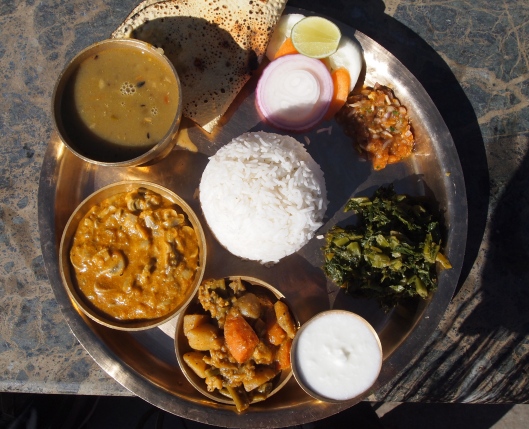
Back in Khasab, we head to a restaurant recommended by The Rough Guide to Oman: Al Shamaliah in the New Souk. I enjoy my favorite fresh mango juice and a very spicy vegetarian Indian dish, while Tom enjoys a “small” mixed grill, which looks quite huge to me, along with a lemon mint drink to which he adds some whiskey to make a mint julep… 🙂
Here we are in Musandam, with a dhow cruise in the cards for us tomorrow morning!
14 Thursday Jun 2012
Posted Khasab, Khasab Hotel, Musandam, Oman
inThursday, June 14: Khasab, Musandam’s major town, sits at the far northern end of the peninsula in a narrow plain between two mountains. It’s one of the few flat pieces of land in all of Musandam. Khasab is home to just about all of Musandam’s accommodation and the choices are slim.
Since the Golden Tulip is expensive and cited by The Rough Guide to Oman as “beginning to look decidedly shabby and unloved, with peeling paint, dated decor and a moribund atmosphere,” we opt for the Khasab Hotel. We’re especially happy to find their double room rates, normally 47 rials ($122), are discounted for the summer (from June 1 to August 17) to 38 rials ($99). This includes all taxes and breakfast.
The Khasab Hotel is pleasantly old-fashioned with low-lying building set around gardens and a pool. There is also an on-site restaurant. We didn’t eat in the restaurant except for breakfast, so I don’t know anything about the quality of the meals.
The hotel offers a full day dhow cruise, a half day dhow cruise, and a mountain safari, including refreshments and fruit. Upon arrival, we signed up for the half-day dhow cruise (9 a.m. – 1 p.m.), which normally cost 15 rials/person, for the following morning. Again, because we’re here during the off-season of summer (because of course it’s miserably hot and humid), we get a discount to 13 rials.
The hotel only accepts CASH payments.
It’s a comfortable mid-range accommodation and we’re perfectly happy with it. The only drawback was that the pool was as warm as a bathtub, so not at all refreshing!
14 Thursday Jun 2012
Posted Khasab, Leilat al-Meiraj, Musandam, Oman
inThursday, June 14: Since we have a surprise holiday ~ a 4-day weekend! ~ for the Prophet’s Ascension (Leilat al-Meiraj), my friend Tom and I decide to take a trip up to Musandam, at the northeastern most tip of the Arabian peninsula. It’s a stand-alone region of Oman, separated by a 70km wide swathe of desert belonging to the United Arab Emirates (UAE), that extends north to the Strait of Hormuz.
According to Oman Off-Road: “Khasab is the northernmost of the four wilayats that make up the governorate of Musandam and is also the capital of the area. This isolated enclave of Oman is known as the ‘fjords of Arabia,’ from the jagged cliffs that plunge into the Gulf of Oman and the Strait of Hormuz to form beautiful hidden inlets – perfect for snorkeling, picnicking and exploring. Until recently, the area was a restricted military zone (to the north is the Strait of Hormuz, through which the majority of the Gulf’s oil trade passes, and Iran is only 45km across the water), but it is now open to civilian visitors.”
We get an early start, sometime around 8:15 a.m., and drive toward Ibri, following Tom’s navigation system, as he has kindly offered to drive his Kia Sportage. Quite a distance after Ibri (it’s about 3 hours total from Nizwa to the border), the navigation system sends us to a border crossing. The crossing seems to be out in the middle of nowhere, with only a few cars passing through. Some confused guards ask us for our passports, and they ask us if we want a stamp. I wonder why on earth they are asking us, when it seems they should be the ones to know if we need a stamp or not. After they stamp our passports, we promptly put them away, not giving them another look.
We see a sign after this border (which it seems later turns out to be a faux border!) showing it is still 40 km to Buraimi, which is still inside of Oman! Tom insists the border we went through was the Hili border post, but later, looking at The Rough Guide to Oman, I think it was the Wadi Jizzi border, which is normally approached from Sohar. How we got to this border I have no idea, as we were just blindly following the GPS.
Here’s what The Rough Guide says: “You will be stamped out of Oman here [Wadi Jizzi border], even though the road beyond the border post is still in Omani territory – you don’t actually reach the UAE border until Al Ain, 40km distant. Entering the UAE from Buraimi, foreigners have to pass through the Hili border post just north of the town center.”
Well. Somehow we never pass through the Hili border and I have no idea how that happens! We just keep driving and following the GPS up toward Musandam, on a 6-lane bypass highway which whizzes us by Dubai, Sharja, and Ras Al Khaimah through salmon-colored sand dunes dotted with more green bushes than I would expect to see in the middle of the desert. We end up at the border post at Tibat.
At Tibat, we encounter a small problem. Though we hadn’t realized it at the time, the border patrols at the off-the-beaten-path Oman border (Wadi Jizzi I believe) only gave us an exit stamp for Oman, but since we never came across another border into UAE, we don’t have an entry stamp into UAE! Now we are trying to leave UAE, and no one can figure out how we got in!!
We are held up for a while, with the border patrols questioning us, but neither of us can say for sure which border we entered UAE through. Tom insists it was Hili, but later, when we leave through the REAL Hili border post going back to Oman, I can see it isn’t the same border! The border patrols make numerous phone calls and it takes some time, but finally, they stamp our passports with the exit stamps, charge us 35 dirhams (around $10) and we head into the northern section of Oman.
Whew! After that hassle is over, we have smooth sailing the rest of the way, driving along a coastal road cut into steep cliffs that fall sharply into the Gulf of Oman. It’s quite scenic and dramatic, but also hazy and hot, about 46 degrees Celsius (!), so the photos are not great. We stop at a couple of places along the way to take pictures of some fishing boats and then head into Khasab, where we check in at the Khasab Hotel.
Official Fairfax County Government Emergency Preparedness, Response and Recovery Website
where travel meets art
~~~In Case You Didn't Know, I Talk 2 Myself~~~
Wrestless Word Wrestler
Encyclopedia Miscellaneous - 'quality' blogging since August 2011
A German Expat's Life in Fredericksburg/Texas
inspired by the colours of the land, sea and sky of Cornwall
A blog about travel adventures written by an Slovenian girl living in Switzerland
Can I have a bite?
Personal blog about running adventures
exploring New York City one adventure at a time
Notes on Seeing, Reading & Writing, Living & Loving in The North
Potato Point and beyond