Thursday, February 7: Last weekend, while I was miserably sick and going back and forth between my bed and the couch, Mario and Anna took a long walk up the Persian steps in Imti, near Izki. They walked up and up those steps for about 3 hours until finally they got tired and turned around and walked back down.

looking toward the Muscat-Nizwa Highway from Jebel Akhdar

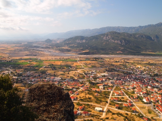
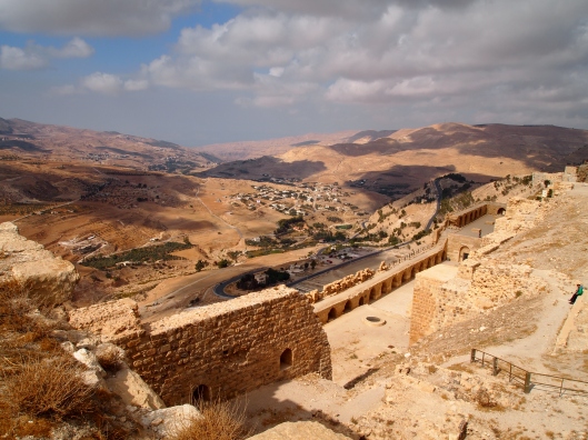
the view toward Izki
Both of them got it in their minds that they wanted to find the top of the Persian steps, otherwise known as the W22 trail, starting from somewhere on Jebel Akhdar, and heading down the mountain until it intersected with the Persian steps that come up from Imti. Once they could find the trail head on Jebel Akhdar, they reckoned, we could drive a car up to that trail head one evening and leave it there overnight. Then the next morning, we could hike up from Imti, all the way to the top of Jebel Akhdar, driving the car back down the mountain after the hike. The plan sounded great — in theory. In reality it was going to be much more difficult than any of us imagined.

morning mountains

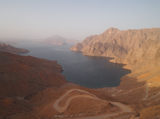
the winding road up Jebel Akhdar
This morning, we go on a quest to find this mystery trail. The problem is that neither Anna nor Mario have a clear idea about how to find the elusive trail head on Jebel Akhdar. Anna tells Kathy, who is driving, to set her odometer to zero somewhere near the bottom of the mountain, before the police checkpoint. She thinks we must start looking for the trail anywhere from 15-25 kilometers up the mountain.

misty mountains

the view toward Izki
On our way up, we see fabulous views of the mountains below with mist hanging in the creases and stop for a photo shoot.

Mario, Kathy & Anna ~ my fellow hikers
At about 15 kilometers, we get out of the car near a big construction site, where there is a kind of graveyard full of concrete barriers. We wander to the edge of the mountain, and we think possibly this area could be the start, but we see no markings to indicate a trail. We decide that we’ll go ahead and drive all the way to the Jebel Akhdar Hotel, past the 25 km mark, where we can ask the hotel staff if they know the directions. We drive slowly to the hotel, looking carefully to the right side of the road for any indication of the trail. We see some possibilities, but again, there is no clear marking.

me, Mario & Anna

flowers can sprout up anywhere in the desert
At the Jebel Akhdar Hotel, we ask about the trail, and the only map the hotel has is of the Saiq Plateau. That won’t help us. Before leaving, we have some coffee and tea, then we head to the police station nearby to ask them if they know of the trail. Sadly none of them speak English. Anna, however, manages to ask them a few questions in her rudimentary Arabic. It seems there is no simple answer, at least not one we can understand.

the Jebel Akhdar Hotel

the inside of the dome in the Jebel Akhdar Hotel lobby
In the meantime, I have been studying two maps. One is from Oman Trekking and the other from Oman Off-Road. Both maps show the trail down to Imti, but there is no landmark on the map as to exactly where the trail intersects the main road. We can see on the map that the trail originates from Hail Al Yemen and goes to the main road, follows the road for a short distance to the left, then turns right toward the edge of the mountain. At least we know how to find Hail Al Yemen. We figure that we will just start at Hail Al Yemen and go until we meet the main road, then we will know where to begin our descent down the mountain.

leaving Hail Al Yemen, we come to a wadi filled with water and several dams

one of the dams in the wadi
It turns out that this is easier said than done. We start out optimistically. From Hail Al Yemen, we descend down into a wadi that actually has a couple of dams in it, and some water. Along the edges of this water source are gardens and grape arbors, but of course nothing is growing at this time of year.

Anna contemplates jumping in
We wander along the edge of this wadi for a while, stopping to climb on top of one of the dams to take pictures of the pools with the mountains reflected in them. Here along these pools and further into the dry wadi, we see interesting plants: palm trees, ornamental grasses, and oleander. The rock formations on the sides of the wadi look like creatures with odd appendages, at least in Kathy’s eyes.

reflections

more reflections

inviting wadi
We continue on down the dry part of the wadi until we come across a number of Omanis and Bangladeshis burning some plants. We ask them about a trail to Imti, and they tell us to continue along the wadi until we see some steps going up on the left. We continue on until we decide to stop for lunch under some trees.

Omanis & Bangladeshis burning plants

This man and his grandson, Abdullah, tell us directions

in the wadi, with fires burning

Omani young guy burning plants

a cheery old Omani man

I love the grasses and the way these green plants glow in the sunlight

in the wadi near our picnic spot

in the wadi

yellow wildflowers in the wadi

rock formations with strange appendages, according to Kathy

a tower rock
Finally, we come to a fork in the wadi and we veer to the left. We almost miss the rough-and-tumble rock steps that blend seamlessly into the canyon wall, but Anna miraculously spots them. We climb up the steps until we have sweeping views of the Saiq Plateau and the village of Saih Katenah across the huge expanse.

the ramshackle Persian steps from Hail Al Yemen

an interesting tree on the way up the steps
When we look ahead, we can’t see any clear trail. In the distance on the left, we see the main road, but Anna and Mario are convinced we don’t head that way. They feel it isn’t in the direction of Imti. To the right we see a roofless building compound and a dirt road winding further up the mountain. They decide we need to head in that direction. There is no trail, but there are plenty of goat droppings, which Mario believes is as good as a trail.

looking back into the wadi from the top of the Persian steps

bird’s eye view
Every once in a while we see faint traces of a trail. We continue on in the direction of that dirt road. From the top of the plateau where we are, we can’t see all the wadis that are between us and that road. It’s only as we walk that we come upon canyon after canyon, where we have to either go to the deep end of the canyon and cross, or climb to the bottom and then climb out again. Finally, after much up and down and up and down, we end up on the dirt road. The climb up the dirt road is steep and strenuous, especially as, by this time, we are exhausted. When we finally reach the main road, we have been hiking about 4 hours.

the mountain terrain on the Saiq Plateau

at the top of the dirt road, here are the canyons where we walked

mountain views
We walk along the main road to the left, as the map shows, but we can’t find the trail which should be near here going down to Imti. We don’t have any intention to continue searching today, as we now know the general vicinity of the trail down. We find an open area where we walk toward the edge of the mountain, past a bunch of goat houses, and then we decide to turn around and head back to the road.

this is near the point where we come out on the road
Back on the road, we put up our thumbs to hitchhike back to our car. Luckily an Omani man with a pick-up truck full of 3 children and reams of groceries offers to let us ride in the back of his pick-up truck back to Hail Al Yemen. By the time we return to our car, we have been hiking for about 6 hours. Before we leave this kind man, I ask him if the place where he picked us up was near the trail to Imti. He said yes, in that area past the goat houses, we should find the trial. Bingo!

Mario & Kathy in the pickup truck as we hitchhike back to our car
Though we don’t find the trail today, we think we are close to solving the puzzle. Next time we know where to start in our search. Stay tuned for the continuing saga.

a goat and its little kid scrambling for milk